


Tracé

ZAMBAUX
User
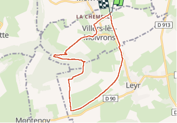

Length
7.9 km

Max alt
419 m

Uphill gradient
203 m
Km-Effort
10.6 km

Min alt
229 m

Downhill gradient
202 m
Boucle
Yes
Creation date :
2022-06-12 17:20:59.431
Updated on :
2022-06-12 17:22:12.45
2h24
Difficulty : Medium

FREE GPS app for hiking
 SityTrail
IGN / Geographical institutes
SityTrail Plus
The world is yours!
About
Trail Walking of 7.9 km to be discovered at Grand Est, Meurthe-et-Moselle, Villers-lès-Moivrons. This trail is proposed by ZAMBAUX.
Description
Rando en partie en forêt
Positioning
Country:
France
Region :
Grand Est
Department/Province :
Meurthe-et-Moselle
Municipality :
Villers-lès-Moivrons
Location:
Unknown
Start:(Dec)
Start:(UTM)
298613 ; 5411009 (32U) N.
Comments