


Vexaincourt

audrey54
User
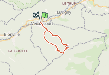

Length
10.4 km

Max alt
803 m

Uphill gradient
449 m
Km-Effort
16.4 km

Min alt
367 m

Downhill gradient
449 m
Boucle
Yes
Creation date :
2022-06-13 08:23:11.0
Updated on :
2022-06-13 10:51:21.416
2h19
Difficulty : Unknown

FREE GPS app for hiking
 SityTrail
IGN / Geographical institutes
SityTrail Plus
The world is yours!
About
Trail Walking of 10.4 km to be discovered at Grand Est, Vosges, Vexaincourt. This trail is proposed by audrey54.
Positioning
Country:
France
Region :
Grand Est
Department/Province :
Vosges
Municipality :
Vexaincourt
Location:
Unknown
Start:(Dec)
Start:(UTM)
355507 ; 5373066 (32U) N.
Comments