


Lachat et Tourbieres 13 06 2022

fra_depoorter
User
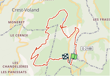

Length
13.1 km

Max alt
1629 m

Uphill gradient
415 m
Km-Effort
18.6 km

Min alt
1441 m

Downhill gradient
409 m
Boucle
Yes
Creation date :
2022-06-13 07:11:33.287
Updated on :
2022-06-13 12:32:48.754
5h18
Difficulty : Medium

FREE GPS app for hiking
 SityTrail
IGN / Geographical institutes
SityTrail Plus
The world is yours!
About
Trail Walking of 13.1 km to be discovered at Auvergne-Rhône-Alpes, Savoy, Crest-Voland. This trail is proposed by fra_depoorter.
Positioning
Country:
France
Region :
Auvergne-Rhône-Alpes
Department/Province :
Savoy
Municipality :
Crest-Voland
Location:
Unknown
Start:(Dec)
Start:(UTM)
307748 ; 5071681 (32T) N.
Comments