


- J2 - Rozelieure - Les Bas Rupts

terrano
User
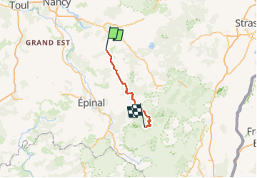

Length
78 km

Max alt
1024 m

Uphill gradient
2087 m
Km-Effort
104 km

Min alt
247 m

Downhill gradient
1538 m
Boucle
No
Creation date :
2022-06-13 17:07:40.074
Updated on :
2022-08-06 17:51:40.778
0m
Difficulty : Very easy

FREE GPS app for hiking
 SityTrail
IGN / Geographical institutes
SityTrail Plus
The world is yours!
About
Trail Electric bike of 78 km to be discovered at Grand Est, Meurthe-et-Moselle, Magnières. This trail is proposed by terrano.
Positioning
Country:
France
Region :
Grand Est
Department/Province :
Meurthe-et-Moselle
Municipality :
Magnières
Location:
Unknown
Start:(Dec)
Start:(UTM)
319989 ; 5368658 (32U) N.
Comments