


Toujours en reco

CDSM 55
User
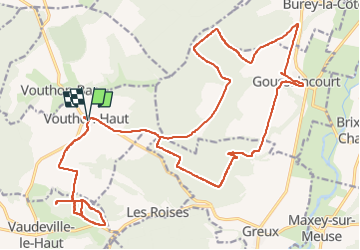

Length
33 km

Max alt
413 m

Uphill gradient
646 m
Km-Effort
41 km

Min alt
263 m

Downhill gradient
648 m
Boucle
Yes
Creation date :
2022-06-13 12:41:11.89
Updated on :
2022-06-13 17:32:54.152
2h48
Difficulty : Medium

FREE GPS app for hiking
 SityTrail
IGN / Geographical institutes
SityTrail Plus
The world is yours!
About
Trail Mountain bike of 33 km to be discovered at Grand Est, Meuse, Vouthon-Haut. This trail is proposed by CDSM 55.
Description
Reconnaissance côté Cumine Vaudeville puis chapelle de Bermont
Positioning
Country:
France
Region :
Grand Est
Department/Province :
Meuse
Municipality :
Vouthon-Haut
Location:
Unknown
Start:(Dec)
Start:(UTM)
693497 ; 5372534 (31U) N.
Comments