


les Cornets en passant par les sources

serge.guerroult
User
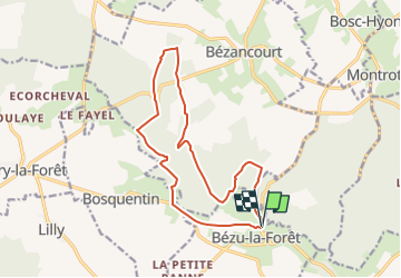

Length
14 km

Max alt
188 m

Uphill gradient
286 m
Km-Effort
17.8 km

Min alt
114 m

Downhill gradient
286 m
Boucle
Yes
Creation date :
2022-06-13 17:58:58.954
Updated on :
2022-08-03 15:31:22.858
3h37
Difficulty : Difficult

FREE GPS app for hiking
 SityTrail
IGN / Geographical institutes
SityTrail Plus
The world is yours!
About
Trail Walking of 14 km to be discovered at Normandy, Eure, Bézu-la-Forêt. This trail is proposed by serge.guerroult.
Positioning
Country:
France
Region :
Normandy
Department/Province :
Eure
Municipality :
Bézu-la-Forêt
Location:
Unknown
Start:(Dec)
Start:(UTM)
400629 ; 5473714 (31U) N.
Comments