


track

CANON2
User
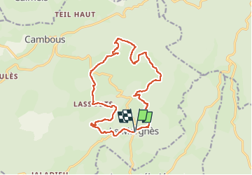

Length
17.5 km

Max alt
1029 m

Uphill gradient
479 m
Km-Effort
24 km

Min alt
763 m

Downhill gradient
489 m
Boucle
Yes
Creation date :
2022-06-14 16:02:24.148
Updated on :
2022-06-14 16:03:19.328
5h25
Difficulty : Medium

FREE GPS app for hiking
 SityTrail
IGN / Geographical institutes
SityTrail Plus
The world is yours!
About
Trail On foot of 17.5 km to be discovered at Occitania, Tarn, Fontrieu. This trail is proposed by CANON2.
Positioning
Country:
France
Region :
Occitania
Department/Province :
Tarn
Municipality :
Fontrieu
Location:
Unknown
Start:(Dec)
Start:(UTM)
467860 ; 4832053 (31T) N.
Comments