


arvieux

ferosine
User
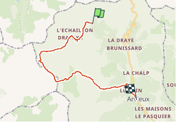

Length
13.8 km

Max alt
2574 m

Uphill gradient
635 m
Km-Effort
24 km

Min alt
1560 m

Downhill gradient
1048 m
Boucle
No
Creation date :
2022-06-15 05:47:08.684
Updated on :
2022-06-23 15:21:09.649
4h32
Difficulty : Medium

FREE GPS app for hiking
 SityTrail
IGN / Geographical institutes
SityTrail Plus
The world is yours!
About
Trail Walking of 13.8 km to be discovered at Provence-Alpes-Côte d'Azur, Hautes-Alpes, Arvieux. This trail is proposed by ferosine.
Photos

Positioning
Country:
France
Region :
Provence-Alpes-Côte d'Azur
Department/Province :
Hautes-Alpes
Municipality :
Arvieux
Location:
Unknown
Start:(Dec)
Start:(UTM)
318668 ; 4963914 (32T) N.
Comments