


2022-06-15_16h56m43_Saint-Gervazy

jeanic63
User
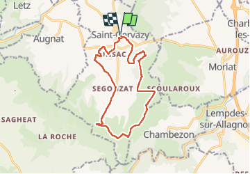

Length
14.3 km

Max alt
740 m

Uphill gradient
286 m
Km-Effort
18.1 km

Min alt
495 m

Downhill gradient
286 m
Boucle
Yes
Creation date :
2022-06-15 14:56:44.603
Updated on :
2022-06-15 15:04:26.613
4h07
Difficulty : Medium

FREE GPS app for hiking
 SityTrail
IGN / Geographical institutes
SityTrail Plus
The world is yours!
About
Trail On foot of 14.3 km to be discovered at Auvergne-Rhône-Alpes, Puy-de-Dôme, Saint-Gervazy. This trail is proposed by jeanic63.
Description
départ parking au centre du village de Saint Gervazy sur la D723
Positioning
Country:
France
Region :
Auvergne-Rhône-Alpes
Department/Province :
Puy-de-Dôme
Municipality :
Saint-Gervazy
Location:
Unknown
Start:(Dec)
Start:(UTM)
516954 ; 5029013 (31T) N.
Comments