


saint agnan

panetJeanLuc
User
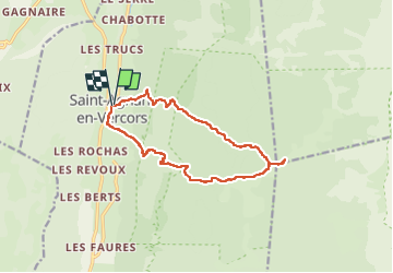

Length
13.8 km

Max alt
1546 m

Uphill gradient
823 m
Km-Effort
25 km

Min alt
776 m

Downhill gradient
824 m
Boucle
Yes
Creation date :
2022-06-16 06:48:23.714
Updated on :
2022-06-16 13:51:03.353
3h53
Difficulty : Very difficult

FREE GPS app for hiking
 SityTrail
IGN / Geographical institutes
SityTrail Plus
The world is yours!
About
Trail Walking of 13.8 km to be discovered at Auvergne-Rhône-Alpes, Drôme, Saint-Agnan-en-Vercors. This trail is proposed by panetJeanLuc.
Positioning
Country:
France
Region :
Auvergne-Rhône-Alpes
Department/Province :
Drôme
Municipality :
Saint-Agnan-en-Vercors
Location:
Unknown
Start:(Dec)
Start:(UTM)
691915 ; 4978752 (31T) N.
Comments