


Villard de lans

Monjean
User
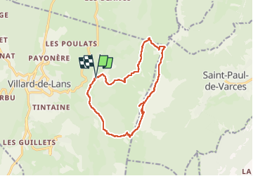

Length
14.5 km

Max alt
2010 m

Uphill gradient
999 m
Km-Effort
28 km

Min alt
1165 m

Downhill gradient
999 m
Boucle
Yes
Creation date :
2022-06-16 07:15:04.962
Updated on :
2022-06-16 15:36:00.089
8h11
Difficulty : Very difficult

FREE GPS app for hiking
 SityTrail
IGN / Geographical institutes
SityTrail Plus
The world is yours!
About
Trail Walking of 14.5 km to be discovered at Auvergne-Rhône-Alpes, Isère, Villard-de-Lans. This trail is proposed by Monjean.
Description
le Cornafion
Positioning
Country:
France
Region :
Auvergne-Rhône-Alpes
Department/Province :
Isère
Municipality :
Villard-de-Lans
Location:
Unknown
Start:(Dec)
Start:(UTM)
703056 ; 4994262 (31T) N.
Comments