


LA JASSE DE MARTINOU

CANON2
User
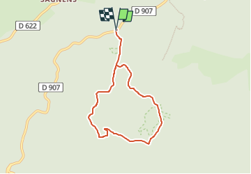

Length
6.9 km

Max alt
1027 m

Uphill gradient
176 m
Km-Effort
9.3 km

Min alt
952 m

Downhill gradient
176 m
Boucle
Yes
Creation date :
2022-06-17 05:50:56.883
Updated on :
2022-06-17 05:51:32.325
2h06
Difficulty : Easy

FREE GPS app for hiking
 SityTrail
IGN / Geographical institutes
SityTrail Plus
The world is yours!
About
Trail On foot of 6.9 km to be discovered at Occitania, Tarn, Lacaune. This trail is proposed by CANON2.
Positioning
Country:
France
Region :
Occitania
Department/Province :
Tarn
Municipality :
Lacaune
Location:
Unknown
Start:(Dec)
Start:(UTM)
473702 ; 4837715 (31T) N.
Comments