


Bas Thorenc 3542 ET

verotrail
User

Length
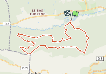
12.4 km

Max alt
1488 m

Uphill gradient
514 m
Km-Effort
19.2 km

Min alt
1123 m

Downhill gradient
514 m
Boucle
Yes
Creation date :
2022-06-17 11:12:51.53
Updated on :
2022-06-17 11:17:02.713
4h22
Difficulty : Medium

FREE GPS app for hiking
 SityTrail
IGN / Geographical institutes
SityTrail Plus
The world is yours!
About
Trail On foot of 12.4 km to be discovered at Provence-Alpes-Côte d'Azur, Maritime Alps, Andon. This trail is proposed by verotrail.

Positioning
Country:
France
Region :
Provence-Alpes-Côte d'Azur
Department/Province :
Maritime Alps
Municipality :
Andon
Location:
Unknown
Start:(Dec)
Start:(UTM)
323611 ; 4851539 (32T) N.
Comments