


chahalot

noelphil
User
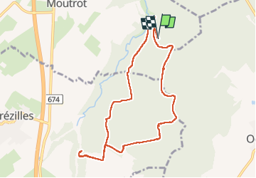

Length
9.2 km

Max alt
289 m

Uphill gradient
116 m
Km-Effort
10.8 km

Min alt
227 m

Downhill gradient
120 m
Boucle
Yes
Creation date :
2022-06-17 12:10:10.16
Updated on :
2022-06-17 16:05:42.462
3h08
Difficulty : Medium

FREE GPS app for hiking
 SityTrail
IGN / Geographical institutes
SityTrail Plus
The world is yours!
About
Trail Walking of 9.2 km to be discovered at Grand Est, Meurthe-et-Moselle, Moutrot. This trail is proposed by noelphil.
Description
trou
Positioning
Country:
France
Region :
Grand Est
Department/Province :
Meurthe-et-Moselle
Municipality :
Moutrot
Location:
Unknown
Start:(Dec)
Start:(UTM)
714967 ; 5386870 (31U) N.
Comments