


220619-StJean.Vetre - Pragnot

randodan
User
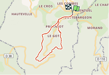

Length
7 km

Max alt
1072 m

Uphill gradient
208 m
Km-Effort
9.8 km

Min alt
873 m

Downhill gradient
218 m
Boucle
Yes
Creation date :
2022-06-19 07:38:18.307
Updated on :
2022-06-21 14:17:17.403
2h40
Difficulty : Medium

FREE GPS app for hiking
 SityTrail
IGN / Geographical institutes
SityTrail Plus
The world is yours!
About
Trail Walking of 7 km to be discovered at Auvergne-Rhône-Alpes, Loire, Saint-Jean-la-Vêtre. This trail is proposed by randodan.
Description
Pragnot, Bois du Plat, Jappeloup,
(Champitière), Les Etivaux.
Positioning
Country:
France
Region :
Auvergne-Rhône-Alpes
Department/Province :
Loire
Municipality :
Saint-Jean-la-Vêtre
Location:
Unknown
Start:(Dec)
Start:(UTM)
562736 ; 5069480 (31T) N.
Comments