


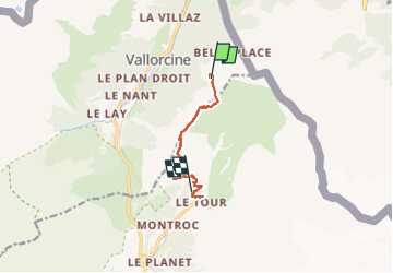
Vallorcine-les Posettes

geranimo
User

Length
6.6 km

Max alt
2195 m

Uphill gradient
349 m
Km-Effort
12.5 km

Min alt
1474 m

Downhill gradient
710 m
Boucle
No
Creation date :
2022-06-19 11:41:04.101
Updated on :
2022-07-05 22:15:21.11
2h50
Difficulty : Difficult

FREE GPS app for hiking
 SityTrail
IGN / Geographical institutes
SityTrail Plus
The world is yours!
About
Trail Walking of 6.6 km to be discovered at Auvergne-Rhône-Alpes, Upper Savoy, Vallorcine. This trail is proposed by geranimo.
Positioning
Country:
France
Region :
Auvergne-Rhône-Alpes
Department/Province :
Upper Savoy
Municipality :
Vallorcine
Location:
Unknown
Start:(Dec)
Start:(UTM)
341273 ; 5099408 (32T) N.
Comments