


Arcenant 19/06

janussity
User
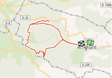

Length
10.2 km

Max alt
552 m

Uphill gradient
277 m
Km-Effort
13.9 km

Min alt
325 m

Downhill gradient
275 m
Boucle
Yes
Creation date :
2022-06-19 07:08:49.796
Updated on :
2022-06-19 12:31:50.576
3h15
Difficulty : Easy

FREE GPS app for hiking
 SityTrail
IGN / Geographical institutes
SityTrail Plus
The world is yours!
About
Trail Walking of 10.2 km to be discovered at Bourgogne-Franche-Comté, Côte-d'Or, Arcenant. This trail is proposed by janussity.
Description
Temps chaud
Photos


Positioning
Country:
France
Region :
Bourgogne-Franche-Comté
Department/Province :
Côte-d'Or
Municipality :
Arcenant
Location:
Unknown
Start:(Dec)
Start:(UTM)
639858 ; 5222157 (31T) N.
Comments