


Villers-Aux-Tours

tatous
User
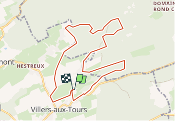

Length
9.9 km

Max alt
278 m

Uphill gradient
185 m
Km-Effort
12.4 km

Min alt
214 m

Downhill gradient
184 m
Boucle
Yes
Creation date :
2022-06-19 16:31:06.876
Updated on :
2022-06-19 16:33:29.587
2h48
Difficulty : Difficult

FREE GPS app for hiking
 SityTrail
IGN / Geographical institutes
SityTrail Plus
The world is yours!
About
Trail Walking of 9.9 km to be discovered at Wallonia, Liège, Anthisnes. This trail is proposed by tatous.
Description
Départ de la Caponière. Targnon - Lagrange
Positioning
Country:
Belgium
Region :
Wallonia
Department/Province :
Liège
Municipality :
Anthisnes
Location:
Unknown
Start:(Dec)
Start:(UTM)
678542 ; 5597420 (31U) N.
Comments