


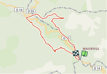
Sentier de Coustorgues Col de Fontfroide

CANON2
User

Length
9.4 km

Max alt
984 m

Uphill gradient
450 m
Km-Effort
15.4 km

Min alt
538 m

Downhill gradient
447 m
Boucle
Yes
Creation date :
2022-06-20 05:13:26.231
Updated on :
2022-06-20 05:44:52.483
3h29
Difficulty : Easy

FREE GPS app for hiking
 SityTrail
IGN / Geographical institutes
SityTrail Plus
The world is yours!
About
Trail On foot of 9.4 km to be discovered at Occitania, Hérault, Saint-Vincent-d'Olargues. This trail is proposed by CANON2.
Description
Sentier de Coustorgues Col de Fontfroide.
Positioning
Country:
France
Region :
Occitania
Department/Province :
Hérault
Municipality :
Saint-Vincent-d'Olargues
Location:
Unknown
Start:(Dec)
Start:(UTM)
489589 ; 4825362 (31T) N.
Comments