


220621-StJean.Vetre PREPA ColBéal

randodan
User
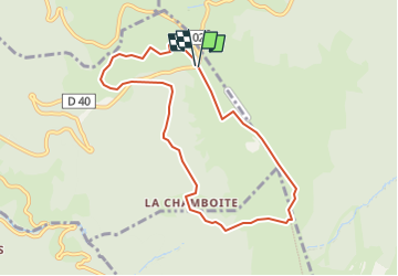

Length
8.2 km

Max alt
1539 m

Uphill gradient
343 m
Km-Effort
12.7 km

Min alt
1258 m

Downhill gradient
343 m
Boucle
Yes
Creation date :
2022-06-20 15:34:05.709
Updated on :
2022-06-21 14:26:16.126
2h53
Difficulty : Difficult

FREE GPS app for hiking
 SityTrail
IGN / Geographical institutes
SityTrail Plus
The world is yours!
About
Trail Walking of 8.2 km to be discovered at Auvergne-Rhône-Alpes, Puy-de-Dôme, Saint-Pierre-la-Bourlhonne. This trail is proposed by randodan.
Description
Col du Béal, etc...
Positioning
Country:
France
Region :
Auvergne-Rhône-Alpes
Department/Province :
Puy-de-Dôme
Municipality :
Saint-Pierre-la-Bourlhonne
Location:
Unknown
Start:(Dec)
Start:(UTM)
560955 ; 5059346 (31T) N.
Comments