


SityTrail - autour du vvf

randodan
User
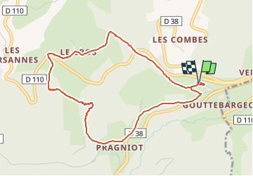

Length
4.8 km

Max alt
936 m

Uphill gradient
161 m
Km-Effort
7 km

Min alt
783 m

Downhill gradient
161 m
Boucle
Yes
Creation date :
2022-06-21 16:28:30.275
Updated on :
2022-06-25 15:52:42.082
1h35
Difficulty : Easy

FREE GPS app for hiking
 SityTrail
IGN / Geographical institutes
SityTrail Plus
The world is yours!
About
Trail Walking of 4.8 km to be discovered at Auvergne-Rhône-Alpes, Loire, Saint-Jean-la-Vêtre. This trail is proposed by randodan.
Description
Belle descente et une montée sur chemin variée
Positioning
Country:
France
Region :
Auvergne-Rhône-Alpes
Department/Province :
Loire
Municipality :
Saint-Jean-la-Vêtre
Location:
Unknown
Start:(Dec)
Start:(UTM)
562714 ; 5069591 (31T) N.
Comments