


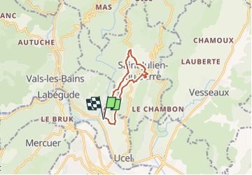
2022-06-22_08h02m53_Viel Ucel Ermitage

Linerou
User

Length
8.7 km

Max alt
425 m

Uphill gradient
260 m
Km-Effort
12.2 km

Min alt
260 m

Downhill gradient
262 m
Boucle
Yes
Creation date :
2022-06-22 06:02:53.52
Updated on :
2022-06-22 06:02:54.57

FREE GPS app for hiking
 SityTrail
IGN / Geographical institutes
SityTrail Plus
The world is yours!
About
Trail of 8.7 km to be discovered at Auvergne-Rhône-Alpes, Ardèche, Ucel. This trail is proposed by Linerou.
Positioning
Country:
France
Region :
Auvergne-Rhône-Alpes
Department/Province :
Ardèche
Municipality :
Ucel
Location:
Unknown
Start:(Dec)
Start:(UTM)
610215 ; 4944003 (31T) N.
Comments