


Bo.uvante le Haut

Monjean
User
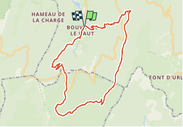

Length
21 km

Max alt
1369 m

Uphill gradient
925 m
Km-Effort
34 km

Min alt
584 m

Downhill gradient
927 m
Boucle
Yes
Creation date :
2022-06-23 06:49:26.95
Updated on :
2022-06-23 14:15:20.535
7h16
Difficulty : Very difficult

FREE GPS app for hiking
 SityTrail
IGN / Geographical institutes
SityTrail Plus
The world is yours!
About
Trail Walking of 21 km to be discovered at Auvergne-Rhône-Alpes, Drôme, Bouvante. This trail is proposed by Monjean.
Description
tubanet.Ambel
Positioning
Country:
France
Region :
Auvergne-Rhône-Alpes
Department/Province :
Drôme
Municipality :
Bouvante
Location:
Unknown
Start:(Dec)
Start:(UTM)
678817 ; 4976904 (31T) N.
Comments