


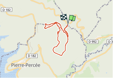
Col de la Chapelotte

lorenzot54
User

Length
6.7 km

Max alt
538 m

Uphill gradient
178 m
Km-Effort
9.1 km

Min alt
462 m

Downhill gradient
176 m
Boucle
Yes
Creation date :
2022-06-24 13:11:11.0
Updated on :
2022-06-25 06:32:27.792
1h52
Difficulty : Medium

FREE GPS app for hiking
 SityTrail
IGN / Geographical institutes
SityTrail Plus
The world is yours!
About
Trail Walking of 6.7 km to be discovered at Grand Est, Meurthe-et-Moselle, Angomont. This trail is proposed by lorenzot54.
Description
Parcours de Dame Galle
Parcours avec très beau rocher, arche
Positioning
Country:
France
Region :
Grand Est
Department/Province :
Meurthe-et-Moselle
Municipality :
Angomont
Location:
Unknown
Start:(Dec)
Start:(UTM)
348945 ; 5372013 (32U) N.
Comments