


Les Tines - Chapeau - Prapator deniv 800m

jeanmarcMasson
User GUIDE
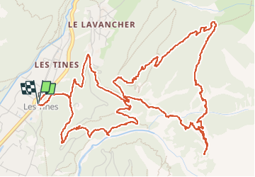

Length
9.9 km

Max alt
1858 m

Uphill gradient
804 m
Km-Effort
21 km

Min alt
1086 m

Downhill gradient
799 m
Boucle
Yes
Creation date :
2022-06-26 07:04:54.116
Updated on :
2022-07-03 06:42:18.269
3h50
Difficulty : Very difficult

FREE GPS app for hiking
 SityTrail
IGN / Geographical institutes
SityTrail Plus
The world is yours!
About
Trail Walking of 9.9 km to be discovered at Auvergne-Rhône-Alpes, Upper Savoy, Chamonix-Mont-Blanc. This trail is proposed by jeanmarcMasson.
Positioning
Country:
France
Region :
Auvergne-Rhône-Alpes
Department/Province :
Upper Savoy
Municipality :
Chamonix-Mont-Blanc
Location:
Unknown
Start:(Dec)
Start:(UTM)
337158 ; 5090632 (32T) N.
Comments