


canal et bonson

eoriol
User

Length
12.3 km

Max alt
429 m

Uphill gradient
95 m
Km-Effort
13.6 km

Min alt
385 m

Downhill gradient
96 m
Boucle
Yes
Creation date :
2022-06-29 07:27:13.461
Updated on :
2022-06-29 08:11:50.493
44m
Difficulty : Easy

FREE GPS app for hiking
 SityTrail
IGN / Geographical institutes
SityTrail Plus
The world is yours!
About
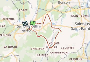
Trail Mountain bike of 12.3 km to be discovered at Auvergne-Rhône-Alpes, Loire, Saint-Marcellin-en-Forez. This trail is proposed by eoriol.
Positioning
Country:
France
Region :
Auvergne-Rhône-Alpes
Department/Province :
Loire
Municipality :
Saint-Marcellin-en-Forez
Location:
Unknown
Start:(Dec)
Start:(UTM)
591247 ; 5038829 (31T) N.
Comments