GR70 Le cheylard - La Bastide

pierrol
User
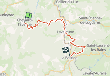

Length
26 km

Max alt
1249 m

Uphill gradient
715 m
Km-Effort
36 km

Min alt
970 m

Downhill gradient
819 m
Boucle
No
Creation date :
2022-06-29 05:52:45.854
Updated on :
2022-06-29 13:50:07.811
6h48
Difficulty : Very difficult

FREE GPS app for hiking
 SityTrail
IGN / Geographical institutes
SityTrail Plus
The world is yours!
About
Trail Walking of 26 km to be discovered at Occitania, Lozère, Cheylard-l'Évêque. This trail is proposed by pierrol.
Positioning
Country:
France
Region :
Occitania
Department/Province :
Lozère
Municipality :
Cheylard-l'Évêque
Location:
Unknown
Start:(Dec)
Start:(UTM)
563699 ; 4944081 (31T) N.
Comments