


![Trail On foot Saint-Jean-des-Ollières - [Itinéraire] Le pic de la Garde - Photo](https://media.geolcdn.com/t/1900/400/ext.pjpeg?maxdim=2&url=https%3A%2F%2Fstatic1.geolcdn.com%2Fsiteimages%2Fupload%2Ffiles%2F1545311037marcheuse_200dpi.jpg)
[Itinéraire] Le pic de la Garde

jeanic63
User

Length
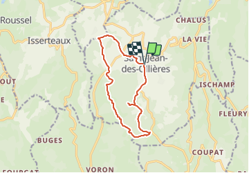
12.2 km

Max alt
772 m

Uphill gradient
347 m
Km-Effort
16.8 km

Min alt
572 m

Downhill gradient
346 m
Boucle
Yes
Creation date :
2022-06-29 16:31:52.901
Updated on :
2023-06-07 15:30:15.647
3h48
Difficulty : Easy

FREE GPS app for hiking
 SityTrail
IGN / Geographical institutes
SityTrail Plus
The world is yours!
About
Trail On foot of 12.2 km to be discovered at Auvergne-Rhône-Alpes, Puy-de-Dôme, Saint-Jean-des-Ollières. This trail is proposed by jeanic63.
Description
Départ : place de l’Église à Saint Jean des Ollières.
Positioning
Country:
France
Region :
Auvergne-Rhône-Alpes
Department/Province :
Puy-de-Dôme
Municipality :
Saint-Jean-des-Ollières
Location:
Unknown
Start:(Dec)
Start:(UTM)
533906 ; 5054622 (31T) N.
Comments
Super