


Bruno010814

maginot
User
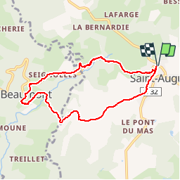

Length
7.8 km

Max alt
562 m

Uphill gradient
199 m
Km-Effort
10.5 km

Min alt
398 m

Downhill gradient
200 m
Boucle
Yes
Creation date :
2014-12-10 00:00:00.0
Updated on :
2014-12-10 00:00:00.0
1h49
Difficulty : Medium

FREE GPS app for hiking
 SityTrail
IGN / Geographical institutes
SityTrail Plus
The world is yours!
About
Trail Walking of 7.8 km to be discovered at New Aquitaine, Corrèze, Saint-Augustin. This trail is proposed by maginot.
Description
Marche à pied temps idéal monte difficile en deuxième parti de parcours
Positioning
Country:
France
Region :
New Aquitaine
Department/Province :
Corrèze
Municipality :
Saint-Augustin
Location:
Unknown
Start:(Dec)
Start:(UTM)
408810 ; 5030977 (31T) N.
Comments