


GTVe J4

PhilippeC54
User
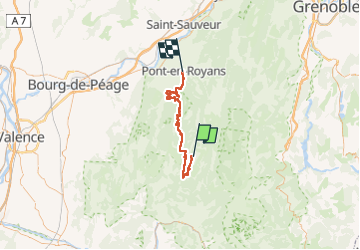

Length
52 km

Max alt
1571 m

Uphill gradient
1367 m
Km-Effort
73 km

Min alt
199 m

Downhill gradient
2223 m
Boucle
No
Creation date :
2022-07-01 06:56:42.839
Updated on :
2022-07-01 14:50:37.944
4h40
Difficulty : Difficult

FREE GPS app for hiking
 SityTrail
IGN / Geographical institutes
SityTrail Plus
The world is yours!
About
Trail Mountain bike of 52 km to be discovered at Auvergne-Rhône-Alpes, Drôme, Vassieux-en-Vercors. This trail is proposed by PhilippeC54.
Positioning
Country:
France
Region :
Auvergne-Rhône-Alpes
Department/Province :
Drôme
Municipality :
Vassieux-en-Vercors
Location:
Unknown
Start:(Dec)
Start:(UTM)
687147 ; 4974069 (31T) N.
Comments