


Aix

raygautier
User

Length
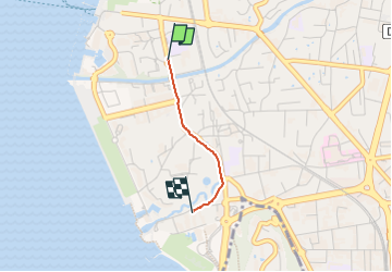
1.1 km

Max alt
239 m

Uphill gradient
2 m
Km-Effort
1.2 km

Min alt
234 m

Downhill gradient
5 m
Boucle
No
Creation date :
2022-07-01 19:45:51.0
Updated on :
2022-07-01 19:59:36.403
12m
Difficulty : Easy

FREE GPS app for hiking
 SityTrail
IGN / Geographical institutes
SityTrail Plus
The world is yours!
About
Trail Walking of 1.1 km to be discovered at Auvergne-Rhône-Alpes, Savoy, Aix-les-Bains. This trail is proposed by raygautier.
Positioning
Country:
France
Region :
Auvergne-Rhône-Alpes
Department/Province :
Savoy
Municipality :
Aix-les-Bains
Location:
Unknown
Start:(Dec)
Start:(UTM)
725096 ; 5065045 (31T) N.
Comments