


GTVe J6

PhilippeC54
User
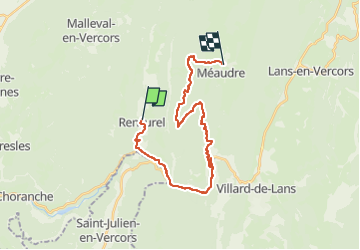

Length
24 km

Max alt
1420 m

Uphill gradient
1042 m
Km-Effort
38 km

Min alt
659 m

Downhill gradient
871 m
Boucle
No
Creation date :
2022-07-03 07:34:13.62
Updated on :
2022-07-03 12:32:32.15
2h07
Difficulty : Medium

FREE GPS app for hiking
 SityTrail
IGN / Geographical institutes
SityTrail Plus
The world is yours!
About
Trail Mountain bike of 24 km to be discovered at Auvergne-Rhône-Alpes, Isère, Rencurel. This trail is proposed by PhilippeC54.
Positioning
Country:
France
Region :
Auvergne-Rhône-Alpes
Department/Province :
Isère
Municipality :
Rencurel
Location:
Unknown
Start:(Dec)
Start:(UTM)
694575 ; 4997491 (31T) N.
Comments