


Falaën ADEPS

thomarche
User
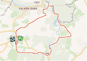

Length
9.8 km

Max alt
246 m

Uphill gradient
240 m
Km-Effort
13 km

Min alt
126 m

Downhill gradient
243 m
Boucle
Yes
Creation date :
2022-07-03 12:09:07.0
Updated on :
2022-07-03 14:36:21.393
2h26
Difficulty : Very easy

FREE GPS app for hiking
 SityTrail
IGN / Geographical institutes
SityTrail Plus
The world is yours!
About
Trail Walking of 9.8 km to be discovered at Wallonia, Namur, Onhaye. This trail is proposed by thomarche.
Description
Boucle avc macadam peu fréquenté. Très beau village tout en pierres. ruines château Montaigle sentier long Flavion.
Positioning
Country:
Belgium
Region :
Wallonia
Department/Province :
Namur
Municipality :
Onhaye
Location:
Unknown
Start:(Dec)
Start:(UTM)
627862 ; 5570768 (31U) N.
Comments