


MN Forêt de la Grange

jeanmarcMasson
User GUIDE
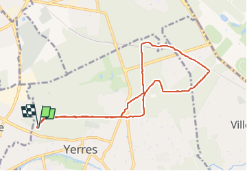

Length
8.8 km

Max alt
121 m

Uphill gradient
120 m
Km-Effort
10.4 km

Min alt
88 m

Downhill gradient
119 m
Boucle
Yes
Creation date :
2022-07-04 07:40:45.136
Updated on :
2022-07-04 09:26:33.547
1h36
Difficulty : Very easy

FREE GPS app for hiking
 SityTrail
IGN / Geographical institutes
SityTrail Plus
The world is yours!
About
Trail Nordic walking of 8.8 km to be discovered at Ile-de-France, Essonne, Yerres. This trail is proposed by jeanmarcMasson.
Positioning
Country:
France
Region :
Ile-de-France
Department/Province :
Essonne
Municipality :
Yerres
Location:
Unknown
Start:(Dec)
Start:(UTM)
461569 ; 5396500 (31U) N.
Comments