


montée Pierre Bérard

Nila81
User
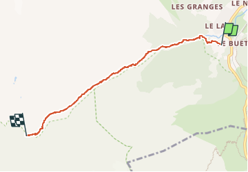

Length
5.3 km

Max alt
1934 m

Uphill gradient
592 m
Km-Effort
11.3 km

Min alt
1355 m

Downhill gradient
18 m
Boucle
No
Creation date :
2022-07-04 07:30:16.281
Updated on :
2022-07-04 09:57:56.304
2h26
Difficulty : Medium

FREE GPS app for hiking
 SityTrail
IGN / Geographical institutes
SityTrail Plus
The world is yours!
About
Trail Walking of 5.3 km to be discovered at Auvergne-Rhône-Alpes, Upper Savoy, Vallorcine. This trail is proposed by Nila81.
Description
az
Positioning
Country:
France
Region :
Auvergne-Rhône-Alpes
Department/Province :
Upper Savoy
Municipality :
Vallorcine
Location:
Unknown
Start:(Dec)
Start:(UTM)
338777 ; 5098238 (32T) N.
Comments