


aiguebelette

whisper73
User
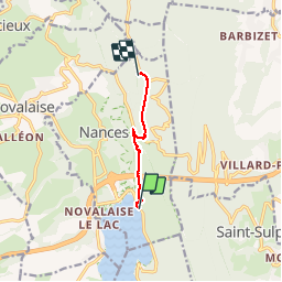

Length
4.9 km

Max alt
1160 m

Uphill gradient
769 m
Km-Effort
12.6 km

Min alt
390 m

Downhill gradient
14 m
Boucle
No
Creation date :
2014-12-10 00:00:00.0
Updated on :
2014-12-10 00:00:00.0
1h37
Difficulty : Medium

FREE GPS app for hiking
 SityTrail
IGN / Geographical institutes
SityTrail Plus
The world is yours!
About
Trail Walking of 4.9 km to be discovered at Auvergne-Rhône-Alpes, Savoy, Nances. This trail is proposed by whisper73.
Description
depuis le lac
Positioning
Country:
France
Region :
Auvergne-Rhône-Alpes
Department/Province :
Savoy
Municipality :
Nances
Location:
Unknown
Start:(Dec)
Start:(UTM)
719030 ; 5050425 (31T) N.
Comments
