


le buet

Nila81
User
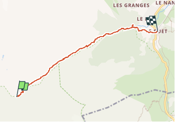

Length
5.7 km

Max alt
1895 m

Uphill gradient
23 m
Km-Effort
7.8 km

Min alt
1344 m

Downhill gradient
570 m
Boucle
No
Creation date :
2022-07-04 11:06:33.922
Updated on :
2022-07-04 13:57:10.626
2h48
Difficulty : Medium

FREE GPS app for hiking
 SityTrail
IGN / Geographical institutes
SityTrail Plus
The world is yours!
About
Trail Walking of 5.7 km to be discovered at Auvergne-Rhône-Alpes, Upper Savoy, Vallorcine. This trail is proposed by Nila81.
Description
retour
Positioning
Country:
France
Region :
Auvergne-Rhône-Alpes
Department/Province :
Upper Savoy
Municipality :
Vallorcine
Location:
Unknown
Start:(Dec)
Start:(UTM)
335118 ; 5096594 (32T) N.
Comments