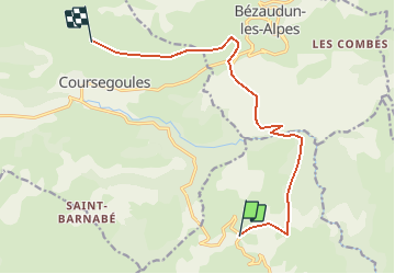
Trail Walking Vence - Rando Riou Cheiron - Photo
© OpenStreetMap contributors
Length
Length
12 km
Max alt
Max alt
1408 m
Uphill gradient
Uphill gradient
877 m
Km-Effort
Km-Effort  
22 km
Min alt
Min alt
640 m
Downhill gradient
Downhill gradient
264 m
Boucle
Boucle
No
Creation date :
2014-12-10 00:00:00.0
Updated on :
2014-12-10 00:00:00.0

(0 Reviews)

Walking
Walking
4h48
Difficulty : Medium

Scan this QR Code to open this trail in the SityTrail application

FREE GPS app for hiking

Logo SityTrail SityTrail

IGN / Geographical institutes

Download SityTrail from the App Store Download SityTrail from Google Play

Logo SityTrail SityTrail Plus

The world is yours!

Download SityTrail from the App Store Download SityTrail from Google Play Download SityTrail on Huawei AppGallery

About

Trail Walking of 12 km to be discovered at Provence-Alpes-Côte d'Azur, Maritime Alps, Vence. This trail is proposed by olivier.loevenbruck.

Description

Départ Parking Plan des Noves
(on pose une voiture au col de Vence, au cas où)
Pause déjeuner dans les vasques naturelles du Riou
Sieste ^^
Bivouac dans les dollines sur la crête du Cheiron
Plusieurs options pour le chemin retour, à discuter plus tard.

Elevation profile

Positioning

Country:
France
Region :
Provence-Alpes-Côte d'Azur
Department/Province :
Maritime Alps
Municipality :
Vence
Location:
Unknown
Start:(UTM)
345982 ; 4846886 (32T) N.


Close
My subscriptions