


mardi G 3

Nila81
User
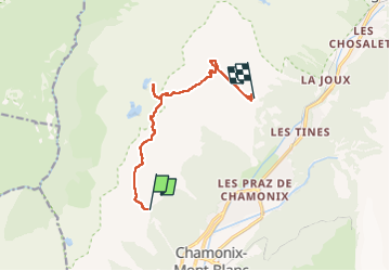

Length
10 km

Max alt
2556 m

Uphill gradient
787 m
Km-Effort
21 km

Min alt
1883 m

Downhill gradient
907 m
Boucle
No
Creation date :
2022-07-05 07:17:08.017
Updated on :
2022-07-05 13:54:00.284
5h45
Difficulty : Very difficult

FREE GPS app for hiking
 SityTrail
IGN / Geographical institutes
SityTrail Plus
The world is yours!
About
Trail Walking of 10 km to be discovered at Auvergne-Rhône-Alpes, Upper Savoy, Chamonix-Mont-Blanc. This trail is proposed by Nila81.
Description
journée
Positioning
Country:
France
Region :
Auvergne-Rhône-Alpes
Department/Province :
Upper Savoy
Municipality :
Chamonix-Mont-Blanc
Location:
Unknown
Start:(Dec)
Start:(UTM)
333595 ; 5089176 (32T) N.
Comments