


Camping La Garrigue

Gegetop
User

Length
14.1 km

Max alt
386 m

Uphill gradient
253 m
Km-Effort
17.5 km

Min alt
313 m

Downhill gradient
253 m
Boucle
Yes
Creation date :
2022-07-05 09:11:04.227
Updated on :
2022-07-06 06:36:28.239
3h50
Difficulty : Medium
3h21
Difficulty : Medium

FREE GPS app for hiking
 SityTrail
IGN / Geographical institutes
SityTrail Plus
The world is yours!
About
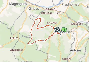
Trail Walking of 14.1 km to be discovered at Occitania, Lot, Loubressac. This trail is proposed by Gegetop.
Description
Départ du camping et boucle dans les calades et murets de pierres sèches à travers bois et pâturages.
Photos

Positioning
Country:
France
Region :
Occitania
Department/Province :
Lot
Municipality :
Loubressac
Location:
Unknown
Start:(Dec)
Start:(UTM)
405206 ; 4969061 (31T) N.
Comments