


La Foret de Thelle de Lincourt au bois du Coudray

serge.guerroult
User
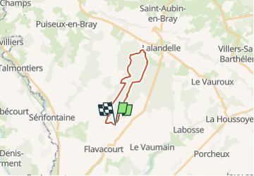

Length
14.3 km

Max alt
239 m

Uphill gradient
272 m
Km-Effort
17.9 km

Min alt
104 m

Downhill gradient
273 m
Boucle
Yes
Creation date :
2022-07-06 17:18:18.647
Updated on :
2022-07-06 17:49:45.33
4h42
Difficulty : Very difficult

FREE GPS app for hiking
 SityTrail
IGN / Geographical institutes
SityTrail Plus
The world is yours!
About
Trail Walking of 14.3 km to be discovered at Hauts-de-France, Oise, Flavacourt. This trail is proposed by serge.guerroult.
Positioning
Country:
France
Region :
Hauts-de-France
Department/Province :
Oise
Municipality :
Flavacourt
Location:
Unknown
Start:(Dec)
Start:(UTM)
415097 ; 5467122 (31U) N.
Comments