Gare de Preles Courcelles a St Martin

avdem
User
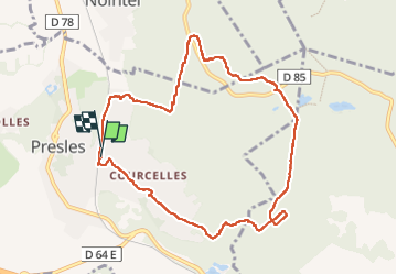

Length
9.6 km

Max alt
211 m

Uphill gradient
203 m
Km-Effort
12.3 km

Min alt
53 m

Downhill gradient
203 m
Boucle
Yes
Creation date :
2022-07-07 07:31:49.202
Updated on :
2022-07-07 10:27:13.046
2h28
Difficulty : Easy

FREE GPS app for hiking
 SityTrail
IGN / Geographical institutes
SityTrail Plus
The world is yours!
About
Trail Walking of 9.6 km to be discovered at Ile-de-France, Val-d'Oise, Presles. This trail is proposed by avdem.
Description
Facile
Positioning
Country:
France
Region :
Ile-de-France
Department/Province :
Val-d'Oise
Municipality :
Presles
Location:
Unknown
Start:(Dec)
Start:(UTM)
448051 ; 5440336 (31U) N.
Comments