Trail Walking Valdeblore - tour du pic de colmiane - Photo
 PhilB24
PhilB24

User

© OpenStreetMap contributors
Length
Length
8 km
Max alt
Max alt
1786 m
Uphill gradient
Uphill gradient
497 m
Km-Effort
Km-Effort  
14.7 km
Min alt
Min alt
1433 m
Downhill gradient
Downhill gradient
497 m
Boucle
Boucle
Yes
Creation date :
2022-07-07 08:50:10.012
Updated on :
2022-07-14 16:51:33.752

(0 Reviews)

Walking
Walking
2h24
Difficulty : Medium

Scan this QR Code to open this trail in the SityTrail application

FREE GPS app for hiking

Logo SityTrail SityTrail

IGN / Geographical institutes

Download SityTrail from the App Store Download SityTrail from Google Play

Logo SityTrail SityTrail Plus

The world is yours!

Download SityTrail from the App Store Download SityTrail from Google Play Download SityTrail on Huawei AppGallery

About

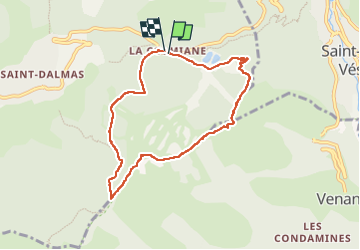
Trail Walking of 8 km to be discovered at Provence-Alpes-Côte d'Azur, Maritime Alps, Valdeblore. This trail is proposed by PhilB24.

Description

Départ de la station de La Colmiane, direction les 2 lacs, récupération du tracé jaune au niveau de la station intermédiaire de la tyrolienne et montée raide par la piste rouge les Airelles.  La deuxieme partie hors station est plus interessante.

Elevation profile

Photos

Positioning

Country:
France
Region :
Provence-Alpes-Côte d'Azur
Department/Province :
Maritime Alps
Municipality :
Valdeblore
Location:
Unknown
Start:(UTM)
357666 ; 4881285 (32T) N.


Close
My subscriptions