


randonnée

CDSM 55
User
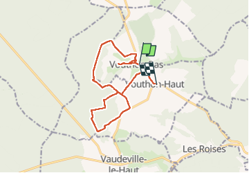

Length
13.4 km

Max alt
445 m

Uphill gradient
231 m
Km-Effort
16.4 km

Min alt
342 m

Downhill gradient
196 m
Boucle
No
Creation date :
2022-07-04 11:47:47.342
Updated on :
2022-07-07 14:02:42.514
73h58
Difficulty : Medium

FREE GPS app for hiking
 SityTrail
IGN / Geographical institutes
SityTrail Plus
The world is yours!
About
Trail Walking of 13.4 km to be discovered at Grand Est, Meuse, Vouthon-Bas. This trail is proposed by CDSM 55.
Positioning
Country:
France
Region :
Grand Est
Department/Province :
Meuse
Municipality :
Vouthon-Bas
Location:
Unknown
Start:(Dec)
Start:(UTM)
692838 ; 5373225 (31U) N.
Comments