


Col de la Croix-Saint Jean d'Arves

nicolas54230
User
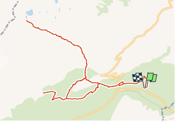

Length
14 km

Max alt
2357 m

Uphill gradient
851 m
Km-Effort
25 km

Min alt
1912 m

Downhill gradient
853 m
Boucle
Yes
Creation date :
2022-07-08 07:04:36.329
Updated on :
2022-07-08 07:05:46.94
5h46
Difficulty : Medium

FREE GPS app for hiking
 SityTrail
IGN / Geographical institutes
SityTrail Plus
The world is yours!
About
Trail On foot of 14 km to be discovered at Auvergne-Rhône-Alpes, Savoy, Saint-Colomban-des-Villards. This trail is proposed by nicolas54230.
Positioning
Country:
France
Region :
Auvergne-Rhône-Alpes
Department/Province :
Savoy
Municipality :
Saint-Colomban-des-Villards
Location:
Unknown
Start:(Dec)
Start:(UTM)
279121 ; 5013374 (32T) N.
Comments