


gavarnie

dewaeph
User
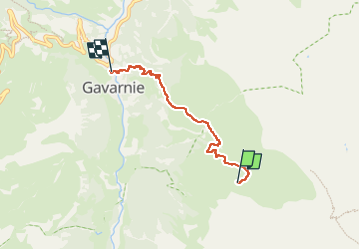

Length
4.3 km

Max alt
2044 m

Uphill gradient
40 m
Km-Effort
6.9 km

Min alt
1373 m

Downhill gradient
682 m
Boucle
No
Creation date :
2022-07-08 14:37:20.838
Updated on :
2022-07-08 16:39:05.747
2h01
Difficulty : Medium

FREE GPS app for hiking
 SityTrail
IGN / Geographical institutes
SityTrail Plus
The world is yours!
About
Trail Walking of 4.3 km to be discovered at Occitania, Hautespyrenees, Gavarnie-Gèdre. This trail is proposed by dewaeph.
Positioning
Country:
France
Region :
Occitania
Department/Province :
Hautespyrenees
Municipality :
Gavarnie-Gèdre
Location:
Gavarnie
Start:(Dec)
Start:(UTM)
255349 ; 4734067 (31T) N.
Comments