


Méré 13-km

papylinlin
User
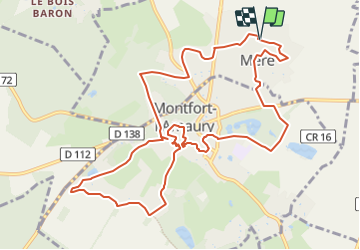

Length
12.1 km

Max alt
183 m

Uphill gradient
168 m
Km-Effort
14.3 km

Min alt
107 m

Downhill gradient
170 m
Boucle
Yes
Creation date :
2022-07-10 10:08:57.826
Updated on :
2023-11-15 09:20:52.018
3h15
Difficulty : Easy

FREE GPS app for hiking
 SityTrail
IGN / Geographical institutes
SityTrail Plus
The world is yours!
About
Trail On foot of 12.1 km to be discovered at Ile-de-France, Yvelines, Méré. This trail is proposed by papylinlin.
Positioning
Country:
France
Region :
Ile-de-France
Department/Province :
Yvelines
Municipality :
Méré
Location:
Unknown
Start:(Dec)
Start:(UTM)
413340 ; 5404562 (31U) N.
Comments