


Cimes et lacs de Lausfer

domi06
User


6h06
Difficulty : Difficult

FREE GPS app for hiking
 SityTrail
IGN / Geographical institutes
SityTrail Plus
The world is yours!
About
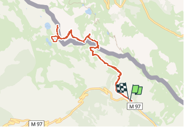
Trail Walking of 10.8 km to be discovered at Provence-Alpes-Côte d'Azur, Maritime Alps, Isola. This trail is proposed by domi06.
Description
Départ B77 Pont de Chastellar sur la route entre Isola et Isola 2000. Passer le pont, tourner à gauche, piste jusqu'au blockhaus, passer devant l'oratoire Ste Anne et grimper le sentier jusqu'au pas de Ste Anne 2308m, puis direction col de Lausfer 2400m. Prendre à droite une petite sente, puis suivre les cairns qui mènent à la cime Sud reconnaissable à sa croix, redescendre quelques mètres, puis se diriger vers la cime nord 2547m. Redescendre au col, puis aux lacs. Reprendre la direction du col, et suivre même trace pour le retour.
Cotation E5/T4/R4
Photos


Positioning
Comments