


st aubinlecauf

dedejojo
User
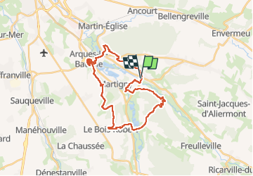

Length
28 km

Max alt
144 m

Uphill gradient
606 m
Km-Effort
36 km

Min alt
4 m

Downhill gradient
602 m
Boucle
Yes
Creation date :
2022-07-10 07:59:40.385
Updated on :
2022-07-10 15:00:29.008
6h58
Difficulty : Very difficult

FREE GPS app for hiking
 SityTrail
IGN / Geographical institutes
SityTrail Plus
The world is yours!
About
Trail Walking of 28 km to be discovered at Normandy, Seine-Maritime, Saint-Aubin-le-Cauf. This trail is proposed by dedejojo.
Positioning
Country:
France
Region :
Normandy
Department/Province :
Seine-Maritime
Municipality :
Saint-Aubin-le-Cauf
Location:
Unknown
Start:(Dec)
Start:(UTM)
369046 ; 5525568 (31U) N.
Comments