


Chemin de Colette

janussity
User
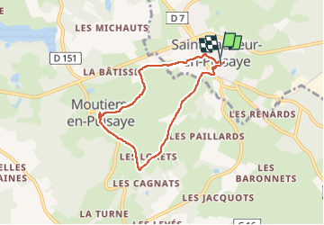

Length
6.3 km

Max alt
289 m

Uphill gradient
121 m
Km-Effort
7.9 km

Min alt
223 m

Downhill gradient
125 m
Boucle
Yes
Creation date :
2022-07-10 13:23:17.098
Updated on :
2022-07-10 15:49:46.653
1h44
Difficulty : Easy

FREE GPS app for hiking
 SityTrail
IGN / Geographical institutes
SityTrail Plus
The world is yours!
About
Trail Walking of 6.3 km to be discovered at Bourgogne-Franche-Comté, Yonne, Saint-Sauveur-en-Puisaye. This trail is proposed by janussity.
Description
Chaud
Photos


Positioning
Country:
France
Region :
Bourgogne-Franche-Comté
Department/Province :
Yonne
Municipality :
Saint-Sauveur-en-Puisaye
Location:
Unknown
Start:(Dec)
Start:(UTM)
514905 ; 5273743 (31T) N.
Comments